
This is the information about the Hierarchy of Trails Routes for covering the OS Landranger sheet OS91 - Appleby-in-Westmorland, Brough and Kirkby Stephen.
A4 map sections at 1:100,000 scale can be downloaded from here. The map sections are suitable for identifying the route accurately, and cross-referencing back to your own OS maps. We recommend that you print these out - and cross-reference back to your OS maps - but do not try to follow the route on the ground from these print outs.
Each survey sheet has grid references to help with route location. The survey sheets are indexed by:
- Byway Open to All Traffic (BOAT) number OR
- Unclassified County Road (UCR) number
You should use the A4 map sheets to confirm the location of the route, it's red / amber / green colour, and its route number. You should then look at the survey sheet to confirm precise grid references and addition survey information to be aware of. The # symbol, where it is printed on the map, means "refer to survey sheet".
In order to build on this information, we would greatly appreciate any feedback, either from recreational vehicle users, or landowners, farmers, local people, walkers, cyclists and horse-riders! You can contact us using the information below.
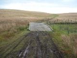
Special Note - Ravenstonedale Moor
The byway at Ravenstonedale Moor (numbers 357087 and 355015) is particularly sensitive - both for historical and nature conservation reasons!
- It is a pre-turnpike route dating back to the 1700s. It was confirmed as a byway in December 2004.
- The terrain is made up of heath moorland and grassy heath on limestone.
- It crosses a Site of Special Scientific Interest (SSSI), mainly related to wading and water bird species. Nearby is Sunbiggin Tarn - thought to be unique in northern England.
This route is likely to be wet at the best of times!
Consequently it is vulnerable to damage by aggressive or careless use of motorcycles or 4x4 vehicles. Bare patches of vegetation will take more than two years to grow back. The four photos at the bottom of this section show the impact of use in wet conditions.
In the days when routes were used with, say, horses and carts to get to market, people tried to find alternative routes in wet weather. Or they might not have got to market at all the next week!
Even a carefully ridden motorcycle will cause damage after wet weather, and (because it is narrow in sections), it should not be attempted by modern 4x4 vehicles. Please always take great care, and if in doubt, find a different way. In Ravenstonedale there are two pleasant single-track tarmac roads that make the same route as the byway.
The byway is passable with care in good weather, but can be avoided after wet conditions. Remember that your wheel ruts stay long after you have gone. Water then collects and runs down the wheel marks, eroding as it goes. This prevents the existing drainage systems from working properly.
We have not put a Traffic Regulation Order on the byway, on the understanding that riders and drivers could be trusted to use their access rights in an environmentally sustainable way. Old byways such as this have a fine history. Please take care so that generations to come can continue to enjoy it.


A4 maps and survey sheets
| Title | Date | Size |
|---|---|---|
| 16/04/2018 | 2688k | |
| 16/04/2018 | 2755k | |
| 16/04/2018 | 2672k | |
| 23/09/2020 | 3019k | |
| 12/01/2017 | 18k | |
| 12/01/2017 | 18k | |
| 29/12/2016 | 18k | |
| 12/01/2017 | 18k | |
| 12/01/2017 | 18k | |
| 12/01/2017 | 20k | |
| 12/01/2016 | 18k | |
| 12/01/2017 | 18k | |
| 12/01/2017 | 21k | |
| 12/01/2017 | 19k | |
| 12/01/2017 | 100k | |
| 12/01/2017 | 18k | |
| 12/01/2017 | 18k | |
| 12/01/2017 | 18k | |
| 12/01/2017 | 19k | |
| 12/01/2017 | 20k | |
| 12/01/2017 | 18k | |
| 12/01/2017 | 19k | |
| 12/01/2017 | 19k | |
| 29/12/2016 | 19k |