The need for fair management of recreational motor vehicle activity was acknowledged in the first Cumbria Countryside Access Strategy by specific reference to the management of recreational motor vehicle activity. The Council consequently produced this guide to the routes where, if the advice is followed, mechanically propelled vehicles (MPVs) can sustainably go for recreation. MPVs mean all motorised vehicles: most 4x4s and trail motorcycles, but also quad bikes. All these vehicles must be road legal, taxed, insured and registered.
The guide aims to manage sustainable levels of activity on routes through voluntary restraint where possible, rather than using statutory measures such as Traffic Regulation Orders. At the same time, the use and condition of routes is monitored. Some routes in sensitive areas can become badly eroded, and in such places recreational motor vehicle users are asked to comply with management measures; for example, one-way traffic systems for vehicles or a route permit system. User organisations are involved in the decision-making and monitoring.
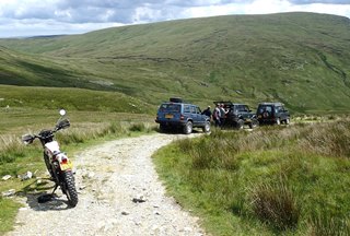
Please note that in order to minimise visual impact and amenity concerns it has been voluntarily agreed that in the Lake District National Park vehicles travelling together should not exceed 6 trail motorcycles or four 4x4 vehicles.
Route colour-coding
Central to the management regime was the allocation of a red, amber, and green colour-code to every trail-route in the county, and a routine of surveys of routes which ensures that the colour code applied to each route remains relevant. Each of the route survey reports included in these web-pages features a colour code to each route.
· Red = Route has a lot of use, proceed with great care and follow advice or signs explaining special controls in place. These routes are under the greatest pressure and there may be environmental issues plus the potential for misunderstanding or conflict with other users.
· Amber = Route has moderate use; proceed with special care - there may be a lot of other users or land management issues. It may not be passable in all weathers.
· Green = Proceed with caution - the route is passable at all times and there may be no management in place.
What has Cumbria County Council done?
Volunteers mainly from the Cumbria Trail Riders Fellowship [TRF] and the Green Lanes Association continue to monitor more than 220 unsurfaced routes to assess suitability and sustainability.
This information can be accessed from the website via downloadable pdfs, and matched up with Ordnance Survey (OS) maps at home. The Survey Sheets should be studied so that users can "know before they go" and plan routes according to the advice given. If the route is incorporated into the Hierarchy it can be can reasonably assumed it is available for use, subject to conditions on the day, Survey Sheet information, and any legal or advisory signs in place.
For reference, the OS (Landranger, 1:50,000) maps required are:
· OS 85 - Carlisle and the Solway Firth area
· OS 86 - (Haltwhistle), Brampton, Bewcastle and Alston area
· OS 89 - West Cumbria, Cockermouth and Wast Water area
· OS 90 - Penrith, Keswick and Ambleside area
· OS 91 - Appleby-in-Westmorland, Brough and Kirkby Stephen area
· OS 96 - Barrow-in-Furness and South Lakeland area
· OS 97 - Kendal, Morecambe Bay and Windermere area
Weather and ground conditions
In recent years periods of increased rainfall have been experienced in Cumbria. This has led to more water based erosion particularly on the steeper tracks which become more vulnerable to surface instability, and to longer periods when low lying routes are waterlogged and vulnerable to damage, particularly by heavier or fast travelling vehicles. Please take this into consideration when planning your itinerary, and decide not to use routes where your passage is likely to cause damage, or make use by farmers, walkers, horse riders and cyclists more difficult. Always be aware that due to conditions on the day - ground and weather conditions etc. - you may have to change your plans. Do not carry on when you may risk causing damage, compromising the landscape, or putting yourself in danger.
What routes have we included?
Since the Natural Environment and Rural Communities Act 2006 routes shown on the Definitive Map as Public Footpath, Public Bridleway and Restricted Byway do not have any public motor vehicle rights of way, and it is a criminal offence to use them without the landowner's permission.
Similarly it is illegal to drive or ride on fields or open land without the landowners' permission. Doing so is particularly liable to cause damage to the landscape and the soil structure, and causes great offence to other groups of recreational users, to local residents, and to farmers and others for whom the land is their livelihood.