Bus Stop Improvements
Cumbria County Council employs a Bus Infrastructure Officer, working as part of the Transport Services Team, who monitors infrastructure at bus stops across the county.
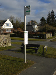
A project to upgrade bus stop infrastructure countywide, arranging the installation of new bus stop flags, marking previously unmarked stops, and replacing crumbling and rusted old bus stop poles with anodised aluminium poles, which include timetable cases where required, has taken place in recent years. All new flags and poles are to a standard design to provide a smart, modern, visible indication of the whereabouts of bus stops, for both local residents and visitors.
The officer is keen to hear from members of the public who are aware of any stops requiring an upgraded pole, flag or timetable case. They can be contacted at: integrated.transport@cumberland.gov.uk with details of proposed locations for upgrades.
Whilst there is currently no specific budget for additional improvements such as raised kerbs, bus shelters, seats, road markings etc, they would also welcome these requests which will be recorded and may be considered in the future.
Bus Stop Repairs
If you see an item of bus stop infrastructure that needs a repair or a replacement, such as a broken bus stop flag, or cracked timetable perspex etc, please contact the Bus Infrastructure Officer via integrated.transport@cumberland.gov.uk with full details of the location and action required.
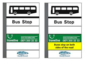
Bus Stop Flags
The standard Cumberland Council bus stop flag designs are shown below, they are made of pvc and the visible area is 50cms by 30cms.
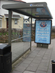
Bus Shelters
Bus shelters round the county are owned by a variety of organisations, Parish, Town, District, City, County councils, or privately. If you wish to report any damage to a bus shelter, or that a shelter is in need of a clean, please email integrated.transport@cumberland.gov.uk with details of the shelter location and the issue. The Bus Infrastructure Officer will forward the issue to the shelter owner.
There is a contract in Barrow and Carlisle, between the County Council and Clear Channel for Clear Channel to maintain, repair and clean shelters carrying advertising plus a small number of other shelters, see the attached list below. If you find damage to any of these shelters, this can be reported directly to Clear Channel on either telephone: 0800 731 3699 or email: ukcallcentre@clearchannel.co.uk
Town / Village | Location |
| Maintainance |
Allonby | By the old chapel, Allonby |
| Allonby Parish Council |
Allonby | Centre of village beside Jim Scotts Joiners |
| Allonby Parish Council |
Allonby | West End |
| Allonby Parish Council |
Applethwaite | Milbeck Road End |
| ? |
Aspatria | Brandraw Car Park |
| Aspatria Town Council |
Aspatria | Harriston Rd End (A) |
| Aspatria Town Council |
Aspatria | Harriston Rd End (B) |
| Aspatria Town Council |
Aspatria | King Street |
| Aspatria Town Council |
Aspatria | King Street |
| Aspatria Town Council |
Aspatria | Lawson Street |
| Aspatria Town Council |
Aspatria | Lawson Street |
| Aspatria Town Council |
Aspatria | Queen Street (Bedford Square) |
| Aspatria Town Council |
Aspatria | Tunnel Bridge (noticeboard) |
| Aspatria Town Council |
Aspatria | Victoria Place |
| Aspatria Town Council |
Aspatria | West Street |
| Aspatria Town Council |
Bassenthwaite | Castle Inn | (f) | Bassenthwaite Parish Council |
Blennerhasset |
|
| Blennerhasset & Torpenhow Parish Council |
Blindcrake |
|
| Blindcrake Parish Council |
Bolton Low Houses |
|
| Boltons Parish Council |
Borrowdale | Fourways (OS 257 142) |
| Borrowdale Parish Council |
Bothel | Adjacent to The Crofts |
| Bothel & Threapland Parish Council |
Bothel | Middle of village |
| Bothel & Threapland Parish Council |
Bothel | Pinfold Green |
| Bothel & Threapland Parish Council |
Braithwaite Village | Opp junction/grass triangle | (f) | Above Derwent Parish Council |
Bridgefoot | next to Chapel Terrace |
| Little Clifton Parish Council |
Bridgefoot | Top of Chapel Brow |
| Little Clifton Parish Council |
Bridgefoot | Top of Chapel Brow |
| Little Clifton Parish Council |
Brigham | School Brow |
| Brigham Parish Council |
Bromfield | Heathfield |
| Bromfield Parish Council |
Bromfield | Leegate |
| Bromfield Parish Council |
Bromfield | Scales |
| Bromfield Parish Council |
Bromfield | Wheyrigg |
| Bromfield Parish Council |
Broughton | Junction of Main St/Harris Brow |
| Broughton Parish Council |
Broughton | Junction of Main St/Kirklea |
| Broughton Parish Council |
Broughton Cross | - |
| Brigham Parish Council |
Broughton Moor | Church Road (1) |
| Broughton Moor Parish Council |
Broughton Moor | Church Road (2) |
| Broughton Moor Parish Council |
Broughton Moor | Opposite Wilsons Terrace |
| Broughton Moor Parish Council |
Broughton Moor | Seaton Road (1) |
| Broughton Moor Parish Council |
Broughton Moor | Seaton Road (2) |
| Broughton Moor Parish Council |
Crosscanonby | Birkby |
| Crosscanonby Parish Council |
Crosscanonby | Crosby (1) |
| Crosscanonby Parish Council |
Crosscanonby | Crosby (2) |
| Crosscanonby Parish Council |
Crosscanonby | Crosby (3) |
| Crosscanonby Parish Council |
Crosscanonby | Crosby (4) |
| Crosscanonby Parish Council |
Crosscanonby | Crosby (5) |
| Crosscanonby Parish Council |
Crosscanonby | Crosby Villa |
| Crosscanonby Parish Council |
Dean | - |
| Dean Parish Council |
Dearham | Sun Inn, Central Road |
| Dearham Parish Council |
Dovenby | The Ship (A59) | (e) | Bridekirk Parish Council |
Dubwath | - map ref NY 198 311 |
| Embleton & District Parish Council |
Embleton | Lambfoot (map ref NY 164 304) |
| Embleton & District Parish Council |
Flimby | adj to Flimby School |
| Maryport Town Council |
Flimby | adj to Princess Royal |
| Maryport Town Council |
Flimby | adj to Railway Station |
| Maryport Town Council |
Flimby | adj. to West Lane |
| Maryport Town Council |
Flimby | opp Flimby School |
| Maryport Town Council |
Grange Bridge | near bridge (OS 254 174) | (f) | Borrowdale Parish Council |
Great Clifton | Gatehead (1) |
| Great Clifton Parish Council |
Great Clifton | Gatehead (2) |
| Great Clifton Parish Council |
Great Clifton | Greengarth (1) |
| Great Clifton Parish Council |
Great Clifton | Greengarth (2) |
| Great Clifton Parish Council |
High Harrington | Brewery House |
| Cumberland Council (ABC) |
High Harrington | Crooklands | (a) | Cumberland Council (ABC) |
High Harrington | Kiln Green | (c) | Cumberland Council (ABC) |
High Harrington | Mountain View | (d) | Cumberland Council (ABC) |
High Harrington | opposite Galloping Horse | (b) | Cumberland Council (ABC) |
Holme Low | Causewayhead corner |
| Holme Low Parish Council |
Ireby | - |
| Ireby & Uldale Parish Council |
Keswick | Latrigg Close, Penrith Road | (f) | Cumberland Council (ABC) |
Keswick | Penrith Road, by war memorial | (d) | Keswick Town Council |
Kirkbride | At Beech Lea (opp School) |
| Kirkbride Parish Council |
Kirkbride | At Grove Cottages |
| Kirkbride Parish Council |
Lorton | Grid Ref NY 153257 |
| Lorton Parish Council |
Low Portinscale | A66 junction |
| ? |
Maryport | adj Crown Inn, Ellenborough (A594) |
| Maryport Town Council |
Maryport | adj to B&M Bargains Store, Curzon Street |
| Maryport Town Council |
Maryport | adj to Cumbria Seafoods (A596) |
| Maryport Town Council |
Maryport | adj to Memorial Gardens (A594) |
| Maryport Town Council |
Maryport | adj to Parkside (A596) |
| Maryport Town Council |
Maryport | adj, Baptist Church, Curzon Street |
| Maryport Town Council |
Maryport | Hillside Ellenfoot Drive |
| Maryport Town Council |
Maryport | jct Ennerdale/ Ewanrigg Roads |
| Maryport Town Council |
Maryport | o/s Doctor's Surgery, Ewanrigg Road. |
| Maryport Town Council |
Maryport | opp Marsh Terrace |
| Maryport Town Council |
Maryport | opp Station Inn, Grasslot |
| Maryport Town Council |
Mealsgate | A595 (Fletchertown turn) | (f) | Boltons Parish Council |
Milbeck | Lane End (near Crookelty) A591 |
| Underskiddaw Parish Council |
Nealhouse | A595 |
| Thursby Parish Council |
Newton Arlosh | centre of village : 'the acre' |
| Holme East Waver Parish Council |
Oulton | opp rd past Institute Hall (nr School) |
| Woodside Parish Council |
Papcastle | Belle Vue | (h) | Papcastle Parish Council |
Plumbland | Bottom of Square |
| Plumbland Parish Council |
Red Dial; | - |
| Westward Parish Council |
Rosthwaite | Middle Howe (OS 258 146) | (f) | Borrowdale Parish Council |
Rosthwaite | Village Turn (OS 258 149) | (f) | Borrowdale Parish Council |
Ruthwaite | - |
| Ireby & Uldale Parish Council |
Seatoller | National Trust Car Park (OS 247 138) | (f) | Borrowdale Parish Council |
Seaton | Coronation Avenue (1) |
| Seaton Parish Council |
Seaton | Coronation Avenue (2) |
| Seaton Parish Council |
Seaton | Derwent Avenue |
| Seaton Parish Council |
Seaton | High Seaton (1) |
| Seaton Parish Council |
Seaton | High Seaton (2) |
| Seaton Parish Council |
Seaton | Jackson Street |
| Seaton Parish Council |
Seaton | Low Seaton |
| Seaton Parish Council |
Siddick | adj Helder Street | (m) | Cumberland Council (ABC) |
Siddick | opp Helder Street | (m) | Cumberland Council (ABC) |
Silloth-on-Solway | Eden Street | (f) | Silloth-on-Solway Town Council |
Silloth-on-Solway | Skinburness Road |
| Silloth-on-Solway Town Council |
Silloth-on-Solway | West Silloth |
| Silloth-on-Solway Town Council |
Stanah | Bridge End, N Bound A591 Grid Ref 315 195 |
| St John's Castlerigg & Wythburn Parish Council |
Stanah | Stanah Lane end, N Bound A591 Grid Ref 316 189 |
| St John's Castlerigg & Wythburn Parish Council |
Thirlmere | Fisher Place, N Bound A591 Grid Ref 316 185 |
| St John's Castlerigg & Wythburn Parish Council |
Thornby | Road End |
| Thursby Parish Council |
Thornthwaite | Village |
| Above Derwent Parish Council |
Threapland | Threapland - village green |
| Bothel & Threapland Parish Council |
Thrushwood | A591 (CA12 4PG approx) |
| Underskiddaw Parish Council |
Thursby | Shaw Wood Road |
| Thursby Parish Council |
Thursby | Ship Inn | b | Thursby Parish Council |
Thursby | village green | w | Thursby Parish Council |
Torpenhow |
|
| Blennerhasset & Torpenhow Parish Council |
Uldale |
|
| Ireby & Uldale Parish Council |
Watchill | - |
| Allhallows Parish Council |
Waverton | Nr Inglewood houses |
| Waverton Parish Council |
Waverton | opp church (A596) |
| Waverton Parish Council |
Wigton | Brindlefield |
| Wigton Town Council |
Wigton | Fairview Court |
| Wigton Town Council |
Wigton | Greenacres |
| Wigton Town Council |
Wigton | Howrigg Bank | (h) | Wigton Town Council |
Wigton | King Street (old Bus Station) | (h) | Wigton Town Council |
Wigton | near Hospital |
| ? |
Wigton | Southend |
| Wigton Town Council |
Wigton | Syke Road |
| Wigton Town Council |
Winscales | Lakes College |
| Winscales Parish Council |
Workington | Bowness Court, Ashfield Road | (h) | Cumberland Council (ABC) |
Workington | Hunday Court Ashfield Road | (h) | Cumberland Council (ABC) |
Workington | Laybourne House, Ashfield Road | (h) | Cumberland Council (ABC) |
Workington | Mossbay Road, end of Solway House Road | (f) | Cumberland Council (ABC) |
Workington | Mossbay Road, junction of Casson Road | (f) | Cumberland Council (ABC) |
Workington | Northside, A596T |
| ? |
Workington | Northside, Mitchell Avenue | (h) | Cumberland Council (ABC) |
Workington | o/s Briary Hob, Stainburn Road | (k) | Cumberland Council (ABC) |
Workington | opp Moorclose Depot, Westfield Drive | (g) | Cumberland Council (ABC) |
Workington | Salterbeck Cemetery | (e) | Cumberland Council (ABC) |
Notes
ABS = Former Allerdale Borough Council shelter
(a) metal and brick | (d) metal and half glass | (g) metal and glass |
(b) metal box | (e) metal | (h) metal and perspex |
(c) wood and brick | (f) brick | (k) metal sporex and glass |
|
| (m) brick and block |
Please Note : This list was put together in 2014. Since when shelters may have been added, removed or ownership transferred
If you are aware of any changes please contact us at integrated.transport@cumberland.gov.uk
Town / Village | Location |
| Maintenance |
Aglionby | A69 near junction for Aglionby | b | Wetheral Parish Council |
Aglionby | A69 near junction for Aglionby | m | Wetheral Parish Council |
Blackford | A7(T), Blackford southbound |
| Rockcliffe Parish Council |
Brampton | A6071 Sands | m | Brampton Parish Council |
Brampton | A6071 Sands | m | Brampton Parish Council |
Brampton | Front Street | m | Cumberland Council (CC) |
Carelton | opposite Border Gate (A6) |
| St Cuthberts Without |
Carelton | opposite Day Centre (A6) |
| St Cuthberts Without |
Cargo | At end of village |
| Kingmoor Parish Council |
Carlisle, Botcherby | Borland Avenue |
| Cumberland Council (CC) |
Carlisle, Botcherby | Holywell Crescent |
| Cumberland Council (CC) |
Carlisle, Botcherby | Victoria Road in, opp Croft Terrace, c/o Botcherby Avenue |
| Clear Channel |
Carlisle, Botchergate | Botchergate in, o/s (The Cumberland Inn) |
| Clear Channel |
Carlisle, Botchergate | Botchergate out, at Portland Place |
| Clear Channel |
Carlisle, Brampton Road | Brampton Road o/s 110 |
| Cumberland Council (CC) |
Carlisle, City Centre | Devonshire Street, o/s Eaten by Monsters |
| Clear Channel (CCC) |
Carlisle, City Centre | English St, The Courts, stand A |
| Clear Channel (CCC) |
Carlisle, City Centre | English St, The Courts, stand B |
| Clear Channel (CCC) |
Carlisle, City Centre | English St, The Courts, stand C |
| Clear Channel (CCC) |
Carlisle, City Centre | English St, The Courts, stand D |
| Clear Channel (CCC) |
Carlisle, City Centre | English St, The Courts, stand E |
| Clear Channel (CCC) |
Carlisle, City Centre | Lonsdale Street, Carlisle Bus Station Bay 4 |
| Stagecoach |
Carlisle, City Centre | Lonsdale Street, Carlisle Bus Station Bay 5 |
| Stagecoach |
Carlisle, City Centre | Lonsdale Street, Carlisle Bus Station Bay 6 |
| Stagecoach |
Carlisle, City Centre | Lonsdale Street, Carlisle Bus Station Bay 7 |
| Stagecoach |
Carlisle, City Centre | Lonsdale Street, Carlisle Bus Station Bay 8 |
| Stagecoach |
Carlisle, City Centre | Stop H Lowther Street |
| Cumberland Council (CC) |
Carlisle, City Centre | Stop I Lowther Street |
| Cumberland Council (CC) |
Carlisle, City Centre | Stop J Lowther Street |
| Cumberland Council (CC) |
Carlisle, City Centre | Stop K West Tower Street, canopy |
| Cumberland Council (CC) |
Carlisle, City Centre | Stop L West Tower Street, canopy |
| Cumberland Council (CC) |
Carlisle, City Centre | Stop M West Tower Street, canopy |
| Cumberland Council (CC) |
Carlisle, City Centre | Stop Q Lowther Street |
| Cumberland Council (CC) |
Carlisle, City Centre | Stop Q Lowther Street, o/s car park |
| Cumberland Council (CC) |
Carlisle, City Centre | Stop R Lowther Street |
| Cumberland Council (CC) |
Carlisle, City Centre | Stop S Lowther Street |
| Cumberland Council (CC) |
Carlisle, City Centre | Stop T Lowther Street |
| Cumberland Council (CC) |
Carlisle, City Centre | The Crescent, stand U |
| Clear Channel (CCC) |
Carlisle, City Centre | The Crescent, stand V |
| Clear Channel (CCC) |
Carlisle, City Centre | West Tower Street, c/o Peter Street, stand N |
| Clear Channel |
Carlisle, City Centre | West Tower Street, opp Scotch Street, stand P |
| Clear Channel |
Carlisle, City Centre | West Tower Street, stand O |
| Clear Channel |
Carlisle, Currock | Blackwell Road, o/s shops, out |
| Cumberland Council (CC) |
Carlisle, Currock | Blackwell Road, opp shops, in |
| Cumberland Council (CC) |
Carlisle, Currock | Blackwell Road, Currock Park Avenue |
| Cumberland Council (CC) |
Carlisle, Dalston Road | Dalston Road, Longsowerby in |
| Cumberland Council (CC) |
Carlisle, Denton Holme | Charlotte Street, Dunelm in |
| Cumberland Council (CC) |
Carlisle, Denton Holme | Denton Road, Metcalfe Street in |
| Cumberland Council (CC) |
Carlisle, Denton Holme | Denton Street |
| Cumberland Council (CC) |
Carlisle, Denton Holme | Junction St in, opp (Royal Mail Depot) |
| Clear Channel |
Carlisle, Denton Holme | Junction Street out, o/s (Royal Mail Depot) |
| Clear Channel |
Carlisle, Denton Holme | Nelson Street, top stop in |
| Cumberland Council (CC) |
Carlisle, Denton Holme | Norfolk Street in |
| Cumberland Council (CC) |
Carlisle, Denton Holme | Norfolk Street out |
| Cumberland Council (CC) |
Carlisle, Denton Holme | Richardson Street, top stop in |
| Cumberland Council (CC) |
Carlisle, Durdar | Newbiggin Road, opp The Black Lion pub |
| Cumberland Council (CC) |
Carlisle, Durranhill | Cumrew Close, Durranhill |
| Cumberland Council (CC) |
Carlisle, Durranhill | Wingate Road | m | Cumberland Council (CC) |
Carlisle, Etterby | Etterby Scaur in |
| Cumberland Council (CC) |
Carlisle, Etterby | Etterby Scaur, opp Redfern, in | m | Cumberland Council (CC) |
Carlisle, Harraby East | Edgehill Road, Arroya pub in | m | Cumberland Council (CC) |
Carlisle, Harraby East | Edgehill Road, Warnell Drive in | m | Cumberland Council (CC) |
Carlisle, Harraby East | Pennine Way, Central Avenue terminus | m | Cumberland Council (CC) |
Carlisle, Harraby East | Pennine Way, Keenan Park | m | Cumberland Council (CC) |
Carlisle, Harraby East | Pennine Way, Springfield Road in | m | Cumberland Council (CC) |
Carlisle, James Street | James Street out, o/s Station Business Park |
| Clear Channel |
Carlisle, Kingstown | Brunthill Road, o/s Bendalls | m | Cumberland Council (CC) |
Carlisle, Kingstown | Chandler Way, Asda |
| Asda |
Carlisle, Kingstown | Kingstown Road in, e/o California Road |
| Clear Channel |
Carlisle, Kingstown | Kingstown Road in, o/s (Gosling Bridge), opp Moorville Drive |
| Clear Channel |
Carlisle, Kingstown | Kingstown Road in, opp Moorville Terrace |
| Clear Channel |
Carlisle, Kingstown | Kingstown Road out, e/o Kingstown Broadway |
| Clear Channel |
Carlisle, Kingstown | Kingstown Road, Lowry Hill Road end in | m | Cumberland Council (CC) |
Carlisle, Kingstown | Parkhouse Road in, o/s (Argos) |
| Clear Channel |
Carlisle, London Road | A6, Bordergate Hotel in | m | Cumberland Council (CC) |
Carlisle, London Road | London Road in, adj No 302 |
| Clear Channel |
Carlisle, London Road | London Road in, o/s (RWP training) |
| Clear Channel |
Carlisle, London Road | London Road in, opp London Road Retail Park (B&Q) |
| Clear Channel |
Carlisle, London Road | London Road in, St Nicholas Retail Park |
| Clear Channel |
Carlisle, London Road | London Road out, opp No.7 Lazonby Terrace |
| Clear Channel |
Carlisle, London Road | London Road out, rear of 46 Lingmoor Way |
| Clear Channel |
Carlisle, London Road | London Road, Carleton School |
| Cumberland Council (CC) |
Carlisle, Lowry Hill | Lowry Hill Road, exit to estate | m | Cumberland Council (CC) |
Carlisle, Morton Park | Ashness Drive | m | Cumberland Council (CC) |
Carlisle, Morton Park | Bannisdale Drive | m | Cumberland Council (CC) |
Carlisle, Morton Park | Langrigg Road, Royal Scot terminus | m | Cumberland Council (CC) |
Carlisle, Morton Park | Levens Drive, near Hallin Crescent | m | Cumberland Council (CC) |
Carlisle, Morton Park | Lyndhurst Gardens | m | Cumberland Council (CC) |
Carlisle, Morton Park | Stonegarth, near shops | m | Cumberland Council (CC) |
Carlisle, Morton Park | Westrigg Road shops | m | Cumberland Council (CC) |
Carlisle, Morton West | Crosshill Drive, Ness Way | m | Cumberland Council (CC) |
Carlisle, Morton West | Orton Road, Hutton Way in | m | Cumberland Council (CC) |
Carlisle, Morton West | Orton Road, Richmond Green in | m | Cumberland Council (CC) |
Carlisle, Morton West | Queensway, junction Orton Road in | m | Cumberland Council (CC) |
Carlisle, Newtown | Infirmary Main Entrance |
| Carlisle Infirmary |
Carlisle, Newtown | Newtown Road in, o/s (Cumberland Infirmary) |
| Clear Channel |
Carlisle, Newtown | Newtown Road, Raffles Avenue in | m | Cumberland Council (CC) |
Carlisle, Old Harraby | Lightfoot Drive, near junction with Petteril Bank Road | m | Cumberland Council (CC) |
Carlisle, Parklands | Cumwhinton Road, Carleton Clinic |
| Carlton Clinic |
Carlisle, Parklands | Garlands Road, Carleton Grange in |
| St Cuthberts Without |
Carlisle, Rosehill | Montgomery Way | m | Cumberland Council (CC) |
Carlisle, Shaddongate | A595 in, o/s (Sainsburys) |
| Clear Channel |
Carlisle, Shaddongate | Church Street in, at (United Biscuits), opp Morton Street |
| Clear Channel |
Carlisle, Shaddongate | Church Street out, by John Street and Shaddongate |
| Clear Channel |
Carlisle, St Aidens | Greystone Road in, Margaret Creighton Gardens |
| Clear Channel |
Carlisle, St Anns | Briar Bank, Community Centre | m | Cumberland Council (CC) |
Carlisle, St Anns | Briar Bank, o/s new builds, old site of Spice Enterprise | m | Cumberland Council (CC) |
Carlisle, Stanwix | Bowscale Close |
| Cumberland Council (CC) |
Carlisle, Stanwix | Scotland Road / Church Street in, at Stanwix car park |
| Clear Channel |
Carlisle, Stanwix | Scotland Road, Lansdowne Crescent in (was Knowe Road) | m | Cumberland Council (CC) |
Carlisle, Stanwix | Scotland Road, Waverley Road in | m | Cumberland Council (CC) |
Carlisle, Upperby | Scalegate Road, Upperby Terminus (67) | m | Cumberland Council (CC) |
Carlisle, Warwick Road | Lakeland Gate (inbound) |
| Clear Channel |
Carlisle, Warwick Road | Tesco (inbound) |
| Clear Channel |
Carlisle, Warwick Road | Warwick Road Tesco's car park | m | Tesco |
Carlisle, Warwick Road | Warwick Road/A69, near Tescos towards M6 jct 43 | m | Cumberland Council (CC) |
Carlisle, Wigton Road | Wigton Road, Peel Street in, |
| Cumberland Council (CC) |
Carlisle, Wigton Road | Wigton Road, Balfour Road in | m | Cumberland Council (CC) |
Carlisle, Wigton Road | Wigton Road, Fairfield Gardens in | m | Cumberland Council (CC) |
Carlisle, Wigton Road | Wigton Road, Horse and Farrier in |
| Cumberland Council (CC) |
Carlisle, Wigton Road | Wigton Road, McVities factory, in |
| Cumberland Council (CC) |
Carlisle, Wigton Road | Wigton Road, Westrigg Road End in |
| Cumberland Council (CC) |
Carlisle, Wigton Road | Wigton Road/Glaramara Drive in |
| Cumberland Council (CC) |
Carlisle, Wigton Road | Wigton Road/Glaramara Drive out |
| Cumberland Council (CC) |
Corby Hill | A69 near Troutbeck Cottage / Co-op | m | Hayton Parish Council |
Corby Hill | A69 opp Roma House, (near traffc lights) | b | Hayton Parish Council |
Corby Hill | A69 opp Troutbeck Cottage / Co-op | b | Hayton Parish Council |
Crosby Moor | A689 o/s Rose Cottage | W | Stanwix Rural Parish Council |
Cummersdale | The Square | m | Cumberland Council (CC) |
Cumwhinton | B6263 at centre of village, westbound | m | Wetheral Parish Council |
Cumwhitton | Opp the village green |
| Cumwhitton Parish Council |
Dalston | B5299 Bridge End |
| Dalston Parish Council |
Dalston | B5299 The Green o/s 48 |
| Dalston Parish Council |
Durdar | Crossroads |
| St Cuthberts Without |
Durdar | Durdar Road, Blackwell terminus |
| Cumberland Council (CC) |
Durdar | opposite common |
| St Cuthberts Without |
Grisdale Bridge | Near bridge |
| Beaumont Parish Council |
Hallbankgate | A689 o/s Belted Will Inn (towards Carlisle) | b | Farlam Parish Council |
Harker | A7(T), Harker Park, towards Carlisle |
| Rockcliffe Parish Council |
Hayton (A69) | Hayton Hall | m | ? |
Hayton (A69) | Hayton Hall Hotel | b | ? |
Hornsby | At end of lane |
| Cumwhitton Parish Council |
Houghton | Houghton Road o/s 32 The Green | m | Cumberland Council (CC) |
Houghton | Houghton Road, Tribune Drive | c | Cumberland Council (CC) |
Houghton | Houghton Road, Tribune Drive | m | Cumberland Council (CC) |
Laversdale | Near telephone box on the green |
| Irthington Parish Council |
Linstock | Village centre |
| Stanwix Rural Parish Council |
Longtown | English Street, Graham Arms Hotel | m | Arthuret Parish Council |
Longtown | English Street, Graham Arms Hotel | m | Arthuret Parish Council |
Longtown | Lovers Lane |
| Arthuret Parish Council |
Longtown | Moor Road opp 45 to 47 |
| Arthuret Parish Council |
Low Crosby | The Stag Inn (opp) |
| Stanwix Rural Parish Council |
Low Row | Middle of Low Row | m | Nether Denton Parish Council |
Penton | At jct with B6318. Crossroads, Warwickland road end |
| Nicholforest Parish Council |
Roadhead | Sleetbeck Road |
| Bewcastle Parish Council |
Rockcliffe | Rockcliffe School |
| Rockcliffe Parish Council |
Sandysike | A7(T), Sandysike jct northbound |
| Arthuret Parish Council |
Sandysike | A7(T), Sandysike jct southbound |
| Arthuret Parish Council |
Scotby | A69 Scotby Road End (outbound) | b | Wetheral Parish Council |
Scotby | A69 Scotby Road End (Wheelbarrow Court) (inbound) | b | Wetheral Parish Council |
Scotby | Park Road westbound towards school | w | Wetheral Parish Council |
Scotby | Scotby Road o/s 21, northbound | b | Wetheral Parish Council |
Todhills | A74(T) opp West View |
| Rockcliffe Parish Council |
Walton | Near village green |
| Walton Parish Council |
Warwick Bridge | A69 near school / Downagate playing fields | b | Wetheral Parish Council |
Warwick-on-Eden | A69 o/s Warwick House | s | Wetheral Parish Council |
Wetheral | Opp the village green | w | Wetheral Parish Council |
Whiteclosegate | Houghton Road | b | Cumberland Council (CC) |
Notes : b = brick / m = metal / W = Wood
CC = Former Carlisle City Council shelter
CCC = Former Cumbria County Council shelter - owned by Cumberland Council but managed by Clear Channel
Please Note : This list was put together in 2014. Since when shelters may have been added, removed or ownership transferred
If you are aware of any changes please contact us at integrated.transport@cummerland.gov.uk
Town / Village | Location | Maintenance |
Arlecdon | Waterloo Terrace | Arlecdon and Frizington Parish Council |
Beckermet | Opposite White Mare public house | Beckermet Parish Council |
Biggrigg | A595, Bankend View junction | Cumberland Council (CBC) |
Biggrigg | A595, Downfield Lane junction | Cumberland Council (CBC) |
Biggrigg | A595, opposite Old Captains House Pub | Cumberland Council (CBC) |
Biggrigg | A595, outside Old Captains House Pub | Cumberland Council (CBC) |
Bootle | A595, Main Street, Captain Shaw's School | Cumberland Council (CBC) |
Bootle | Bootle Station | Cumberland Council (CBC) |
Bootle | Hycemoor Way | Cumberland Council (CBC) |
Bransty | Bransty Road, junction with The Crescent | Cumberland Council (CBC) |
Cleator | Main Street, Opposite the Post Office | Cumberland Council (CBC) |
Cleator | Trumpet Terrace, near St Mary's Church | Cumberland Council (CBC) |
Cleator Moor | Bowthorn | Cumberland Council (CBC) |
Cleator Moor | Ennerdale Road, William Morris Avenue junction | Cumberland Council (CBC) |
Cleator Moor | Keekle Terrace | Cumberland Council (CBC) |
Cleator Moor | Mill Hill (Eastbound) | Cumberland Council (CBC) |
Cleator Moor | Mill Hill (Westbound) | Cumberland Council (CBC) |
Cleator Moor | The Square near library (towards Whitehaven) | Cumberland Council (CBC) |
Distington | A595 at Dismantled Railway Bridge | Cumberland Council (CBC) |
Distington | Common End opposite Castle Pub | Cumberland Council (CBC) |
Distington | Main Street near A595 junction (North) | Cumberland Council (CBC) |
Distington | Main Street near A595 junction (South) | Cumberland Council (CBC) |
Distington | Main Street, Hinnings Road junction | Cumberland Council (CBC) |
Drigg | B5344 Station Road junction | Cumberland Council (CBC) |
Egremont | A595 Outside Cemetery | Cumberland Council (CBC) |
Egremont | A595 St Thomas Cross Roundabout | Cumberland Council (CBC) |
Egremont | Main Street, outside Old Hall | Cumberland Council (CBC) |
Egremont | Main Street, outside Red Lion | Cumberland Council (CBC) |
Frizington | Barratt Estate, Frizington Road | Arlecdon and Frizington Parish Council |
Frizington | Library Main Street (Pencil Fence) | Arlecdon and Frizington Parish Council |
Frizington | Main Street, Moor Place | Cumberland Council (CBC) |
Gosforth | Petton Place, The Square junction | Cumberland Council (CBC) |
Haverigg | Main Street, Townhead junction | Cumberland Council (CBC) |
Haverigg | North Lane Main Street junction | Cumberland Council (CBC) |
Haverigg | Poolside, Main Street junction | Cumberland Council (CBC) |
Hensingham | Caldbeck Road, Red Lonning | Cumberland Council (CBC) |
Hensingham | Cleator Moor Road, outside School | Cumberland Council (CBC) |
Hensingham | Egremont Road, Homewood Road junction | Cumberland Council (CBC) |
Hensingham | Egremont Road, Rutland Avenue junction | Cumberland Council (CBC) |
Hensingham | Homewood Road, opposite Hospital | Cumberland Council (CBC) |
Hensingham | Main Street, opposite Thornton Road junction | Whitehaven Town Council |
Hensingham | opposite Distressed Sailor pub | Cumberland Council (CBC) |
Hensingham | outside St John's Church, Lincoln Road junction | Cumberland Council (CBC) |
Hensingham | Richmond Hill Road | Cumberland Council (CBC) |
Hensingham | Square, adjacent to Car Park | Cumberland Council (CBC) |
Hensingham | Square, opposite St John's Church | Cumberland Council (CBC) |
Keekle | Keekle Road | ? |
Kells | Ennerdale Terrace | Cumberland Council (CBC) |
Kells | Solway Road, High Road junction | Cumberland Council (CBC) |
Kirksanton | Opposite the village green, A5093 | Whicham Parish Council |
Lamplugh | A5086 - near to Lamplugh Cross Pub | Lamplugh Parish Council |
Millom | Moor Road, Horn Hill junction | Cumberland Council (CBC) |
Millom | St George's Road (Market Square) | Millom Town Council |
Mirehouse | Meadow Road, Dalegarth Avenue junction | Cumberland Council (CBC) |
Mirehouse | Meadow Road, Shops | Cumberland Council (CBC) |
Mirehouse | Whinlatter Road, adjacent to Snebro Avenue | Cumberland Council (CBC) |
Mirehouse | Whinlatter Road, Crown & Mitre Pub | Cumberland Council (CBC) |
Moor Row | A595, Moor Row junction (in) | Cumberland Council (CBC) |
Moor Row | A595, Moor Row junction (out) | Cumberland Council (CBC) |
Mowbray | Frizington Road | Arlecdon and Frizington Parish Council |
Parkside | Parkside Road | Cumberland Council (CBC) |
Parton | A595 Screel View junction (Northbound) | Cumberland Council (CBC) |
Parton | A595 Screel View junction (Southbound) | Cumberland Council (CBC) |
Parton | Criffel Road, on estate | Parton Parish Council |
Rowrah | A5086, outside Edgars Garage | Cumberland Council (CBC) |
Seascale | Gosforth Road, Outside School | Cumberland Council (CBC) |
Sellafield | Sellafield, outside main gates | Sellafield Limited. |
St Bees | Fairladies off Main Street | Cumberland Council (CBC) |
The Green | off A5093, outside Village Hall | Cumberland Council (CBC) |
The Hill | A5093, Hodgson Terrace | Cumberland Council (CBC) |
Thornhill | A595, Thornhill junction | Cumberland Council (CBC) |
Thornhill | Village centre on edge of park on The Crescent | Beckermet Parish Council |
Waberthwaite | A595, opposite Brown Cow pub | Cumberland Council (CBC) |
West Lakes | Science Park A595 (in) | Cumberland Council (CBC) |
West Lakes | Science Park A595 (out) | Cumberland Council (CBC) |
Whitbeck | A595, near Church | Cumberland Council (CBC) |
Whitehaven | Bransty Row, opposite old Bus Station | Cumberland Council (CBC) |
Whitehaven | Duke Street | Cumberland Council (CBC) |
Whitehaven | Lowther Street, opposite St Nicholas | Cumberland Council (CBC) |
Whitehaven | Lowther Street, outside Castle | Cumberland Council (CBC) |
Whitehaven | New Road junction A595 | Cumberland Council (CBC) |
Whitehaven | New Road, Pelican Garage | Whitehaven Town Council |
Whitehaven | Newtown | Cumberland Council (CBC) |
Whitehaven | Woodhouse Road | Whitehaven Town Council |
Woodend | A5086, Woodend junction | Cumberland Council (CBC) |
Woodhouse | Woodhouse Road, Adjacent to CBC area office | Cumberland Council (CBC) |
Please Note :
CBC : Former Copeland Borough Council shelters
This list was put together in 2014. Since when shelters may have been added, removed or ownership transferred
If you are aware of any changes please contact us at integrated.transport@cumberland.gov.uk